


Choose your adventure on this ride
Rough asphalt and smooth gravel take you to a scenic lake, and the location of an historic forest fire.
How to get there
The ride begins at the well-signed Little Tupper Lake Headquarters (aka Little Tupper Lake Boat Launch), which is located along Hamilton County Route 10, in Long Lake. County Route 10 and County Route 10A, which are located to the north, are together also known as Circle Road (and Sabattis Circle Road). Coming from the north from the town of Tupper Lake, you would turn right onto County Route 10A while from the south from the town of Long Lake, you would turn left onto County Route 10. Along the easterly end of Little Tupper Lake, County Route 10A ends and the road that continues along the lake and to the start of the ride is still County Route 10 (which is now called the Sabattis Road). (Coordinates: 44.049728, -74.583411)
By the numbers
- Level of difficulty: Easy, Intermediate, or Difficult
- Route length: Easy 9.2 miles (14.8 km), Intermediate 14.2 miles (22.8 km), Difficult 25.6 miles (41.2km)
- Elevation gain/loss: Easy 600 feet (183 m), Intermediate 940 feet (286 m), Difficult 1,680 feet (512 m)
- Rough pavement intermixed with loose gravel and loose stones/gravel over dirt. The difficult ride adds on 11.4 miles of rugged dirt best suited for fatter tires.
Explore the landscapes
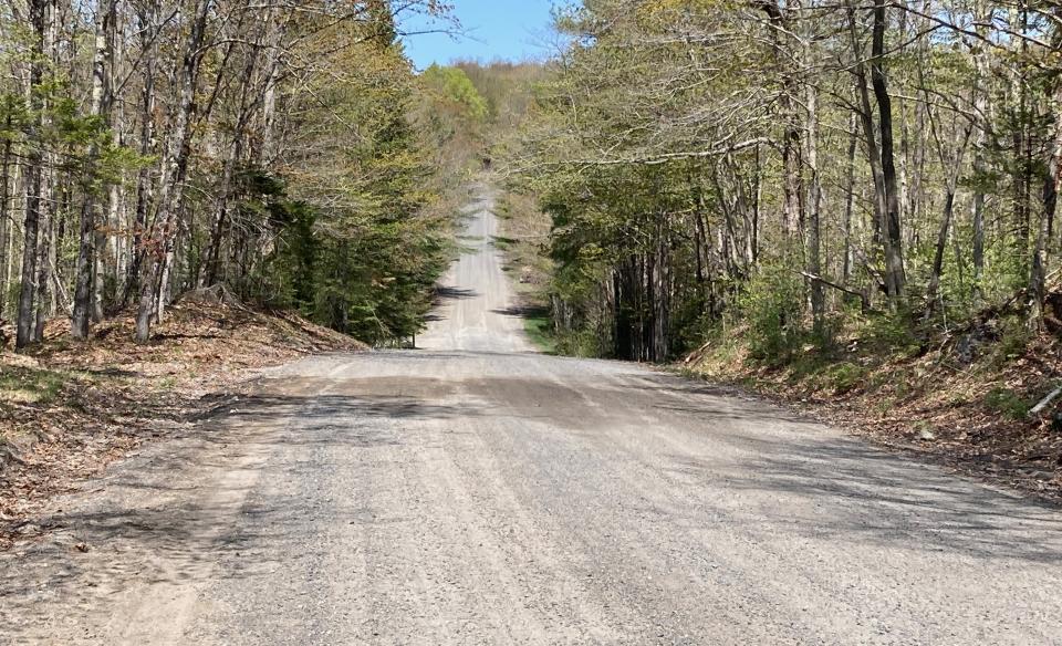
Once you turn into the Little Tupper Lake Headquarters of the William C. Whitney Forest Preserve tract, follow the signs to a large parking lot to unload your bikes and begin this ride. No matter what length you choose, it will undoubtedly serve as a bit of a challenge. As you head out you continue along County Route 10 (aka Sabattis Road), a roughly paved and dirt/gravel road that is smooth and wide. But while smooth, there are locations where a top layer of loose gravel and stones will command your attention and these sections are especially prevalent on the hills. When descending all but the gentlest of hills, speed control is important.
The easy route
The road rolls across the landscape and past small pockets of wetlands, which are excellent places to keep an eye out for wildlife. As you make your way along, the road bisects large tracts of private forest that will likely be under active logging operations. This activity results in mid-week logging truck traffic. It also results in the opening of the forest canopy, which allows light penetration to the forest floor. This then promotes the growth of small trees and shrubs which provides an excellent forage base for moose. Keep your eyes open for this majestic creature, especially in early mornings or later evenings. Footprints left by these creatures on the soft shoulders of the road can be seen any time of day.
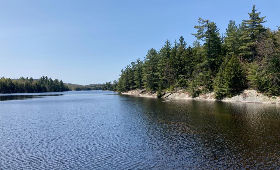
After 4.6 miles, the road crosses a natural causeway over Bear Pond. This is a great spot to stop and soak in the tranquility of the forest and spectacular lake. This is also the turnaround point for the Easy ride.
Intermediate to difficult
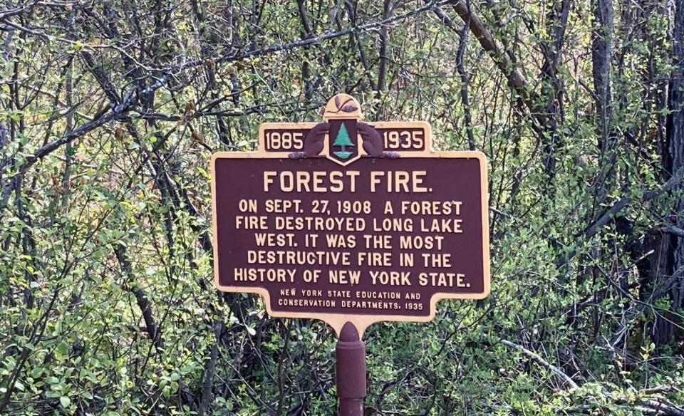
If you’re up for the Intermediate or Difficult distance, you continue another 2.5 miles until you roll into a gravel clearing that includes a historic marker commemorating the location as the site of the most destructive forest fire in New York State’s history. The fire, which occurred in 1908, burned the forest for miles in all directions. It also destroyed the community of Long Lake West, which was regarded by some as one of the most prosperous villages in the Adirondacks. Newspapers of the time reported that the fire resulted in the ignition of over 4 tons of dynamite that was stored in the village, and it burned so hot that barrels of nails melted into lumps, and railroad cars became nothing more than “tangled masses of bent and twisted metal.” Historic forest fires and the destructive logging practices used in the late 19th and early 20th centuries shaped the modern Adirondack Park; the histories of these activities, and the evolution of logging, are well documented in the Adirondack Experience the Museum on Blue Mountain Lake, a beautiful museum located in Blue Mountain Lake, which is only a 30-minute drive south of the starting point of the ride.
The gravel clearing marks the turn-around for both the Intermediate and Difficult rides, with the Intermediate ride retracing to the start of the ride.
Additional miles
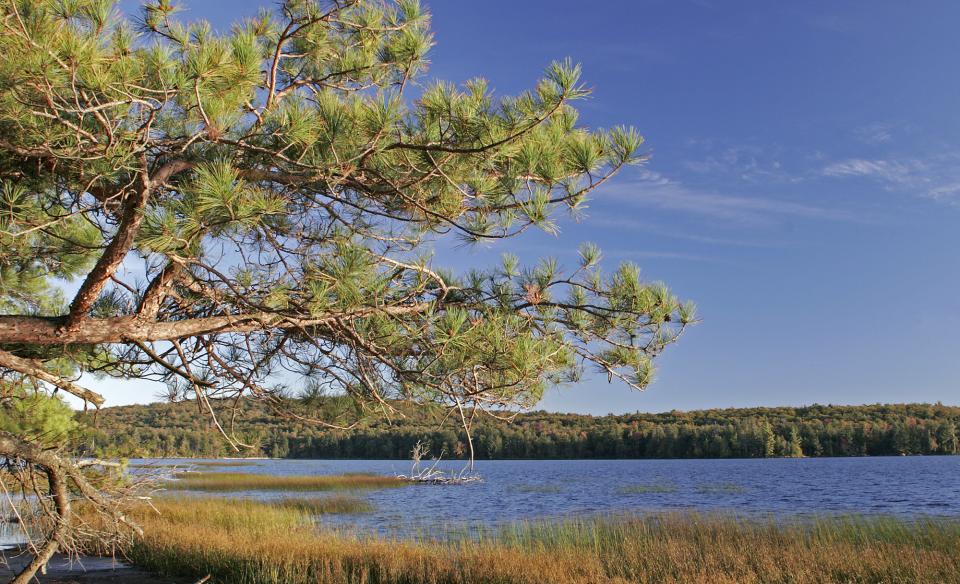
For those intending to do an additional 11.4 miles of more difficult riding, a right turn on onto well-signed Lake Lila Road starts the challenge. The turn is 2.5 miles from the turnaround, and it is located at the bottom of a steep hill. Be forewarned, this is a rather rugged road (which is not included on the RideWithGPS map) best suited for fat tire bikes. The reward for heading down Lake Lila Road is not only the ride itself but the view of Lake Lila, which is just a short walk (and a great place to take a break) from the parking area.
Post-ride
Regardless of the ride you choose, once you return to the parking lot, stow your gear, grab a windbreaker, and walk over to the shoreline of Little Tupper Lake for a well-deserved post-ride break or swim.
Due to limited cellular coverage, please be sure to download this route and save it for offline use before you leave home.